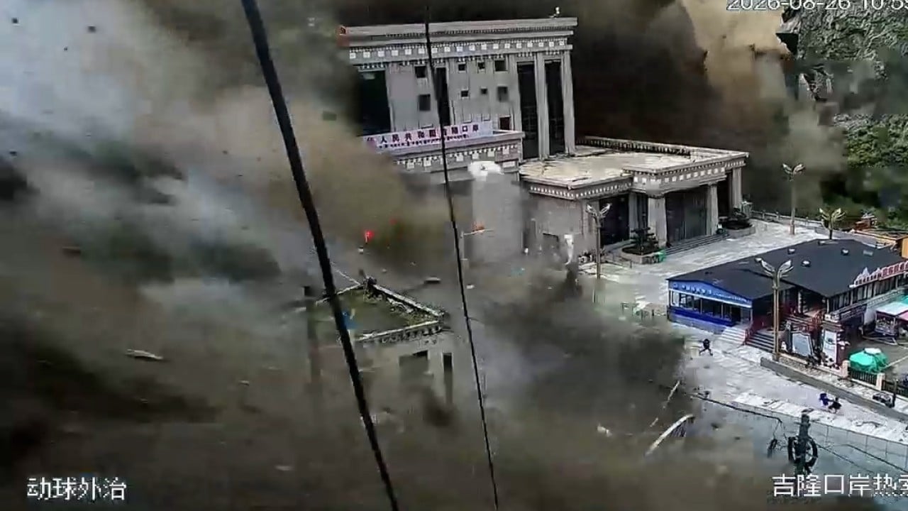
When a massive snow-rock landslide and subsequent debris flow slammed into the China-Nepal border at Gyirong Port and the Rasuwagadhi corridor, it didn't just wipe out roads and buildings. It exposed the brutal fragility of trade and human life in the high Himalayas. Security footage captured the disaster unfolding in seconds, showing muddy torrents tearing through the valley and leaving behind a staggering death toll of over 160 people, with hundreds more missing.
If you look past the initial shock of the doomsday-like footage, this catastrophe highlights a repeating cycle of environmental and infrastructural failure that few want to talk about honestly.
The Trigger Behind the Chaos
What actually happened in those remote valleys? Initial satellite imagery analysis from organizations like Planet Labs and reports from Nepal's National Disaster Risk Reduction and Management Authority pointed to a snow-rock avalanche on the border, roughly 20 kilometers northeast of the Rasuwagadhi crossing. This mass crashed into the Lhende River, creating a temporary debris dam.
When that unstable natural dam burst, it unleashed a violent, cement-thick flash flood down the Bhote Koshi and Trishuli river basins. To compound the crisis, the German Research Centre for Geosciences noted a magnitude 4.4 earthquake rumbling through Tibetan territory just minutes before the disaster timestamp.
Whether the quake triggered the slide or a destabilized glacier gave way first under rising regional temperatures, the result was identical: a catastrophic wall of water and debris that erased local settlements, hydropower stations, and critical transport links.
Why the China Nepal Border Corridor is a High-Risk Bottleneck
We treat mountain border crossings like standard asphalt highways, but they are living, volatile geological hazards. Gyirong Port and Rasuwagadhi aren't just minor checkpoints; they are vital economic lifelines under Beijing and Kathmandu's Trans-Himalayan connectivity networks. Since freight and passenger clearance fully resumed post-pandemic, billions in Chinese exports—including electric vehicles and heavy industrial goods—flow through these steep gorges.
The problem is that the Hindu Kush Himalaya region is warming twice as fast as the global average. Glaciers are melting at unprecedented rates, forming unstable supraglacial lakes and leaving behind loose moraine walls. When heavy monsoon rains or localized seismic shakes hit these fragile slopes, they trigger chain-reaction disasters. A single icefall turns into a blocked river, which becomes a bursting flood wave that wipes out bridges and power grids miles downstream.
We saw a grim preview of this during previous floods on the Bhote Koshi, yet regional planning keeps prioritizing rapid economic integration over long-term climate resilience.
The Human Cost and Rescue Realities
Statistics rarely capture the sheer human weight of these events. Search and rescue operations faced impossible conditions. Thick mud, continuous rain, and washed-out access roads crippled early response efforts on both sides of the frontier.
Hundreds of travelers, including religious pilgrims, foreign nationals from South Korea, the US, and the UK, alongside scores of local residents and workers, vanished into the grey torrents. Downstream in India, particularly in northern states like Bihar and Uttar Pradesh, emergency alerts forced the evacuation of thousands as swollen rivers threatened to breach their banks.
Rescuers deployed drones, 3D laser scanners, and heavy earthmovers, but when an entire valley floor is scoured down to bedrock, finding survivors becomes a race against time and unstable weather.
Moving Beyond Reactive Disaster Management
Governments love to pledge "all-out rescue efforts" after the cameras arrive, but reactive politics won't stop the next mountain collapse. If trade corridors like the China-Nepal border are going to survive this century, the engineering playbook has to change.
We need real-time sensor networks tracking high-altitude glacial movement, automated early-warning sirens linked directly to downstream villages, and infrastructure built miles away from active riverbeds rather than hugging the valley floors. Until regional authorities treat the Himalayas as an active, high-risk hazard zone rather than a convenient trade shortcut, these devastating floods will keep rewriting the border map.



.png)