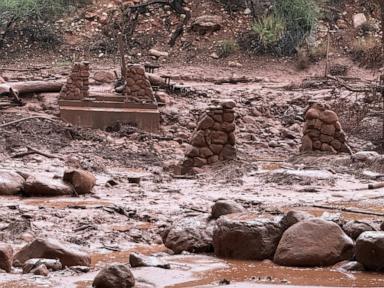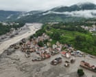
The physical collapse of the Indian Himalayas is no longer a distant theoretical trajectory predicted by climate models; it is an unfolding structural emergency rewriting the geography of South Asia. Recent catastrophic flash floods and massive ice-rock avalanches across the trans-Himalayan corridors have demonstrated that the frozen architecture holding up the roof of the world is failing under the combined weight of atmospheric heating and reckless infrastructural engineering.
When millions of tons of stone and liquefied glacial mass scour river valleys clean in a matter of minutes, the traditional equations of disaster management are rendered obsolete. The structural integrity of the mountains is degrading because the permafrost acting as geological mortar is thawing.
The Mechanics of High-Altitude Collapse
To understand why the mountain terrain is giving way, one must look beyond routine monsoon rainfall and examine the cryosphere. Permafrost is permanently frozen ground that functions as the literal glue holding steep vertical rock faces together. As regional temperatures rise at roughly twice the global average, that thermal baseline shifts above zero degrees Celsius.
Rock slopes that have remained stable for millennia lose their internal cohesion. When an upper hanging glacier or a destabilized cliff section detaches—often triggered by minor seismic tremors or localized hydrofracturing—it initiates a hyper-mobile debris flow.
The resulting mass does not simply slide down a hill. It bulk-samples earth, trees, and infrastructure, turning into an avalanche of mud and boulders that displaces rivers by vertical meters within seconds.
Consider a hypothetical engineering project in a narrow Himalayan gorge. If a construction crew carves deep toe-cuts into the base of a steep slope to lay foundations for a highway or a run-of-the-river hydroelectric plant, they temporarily relieve weight at the bottom while ignoring the massive, destabilized structural load thousands of meters above. When a high-altitude thermal shock hits, the engineered corridor becomes a natural funnel. The geography ensures that any catastrophic discharge from the upper ridges is violently compressed into a high-velocity hydraulic battering ram aimed directly at downstream human settlements.
The Concrete Trap in the Valleys
Economic pressures have forced populations and state planners into a fatal spatial convergence. Flat, stable land is scarce across the Himalayan arc. Consequently, roads, pilgrimage routes, sprawling commercial hubs, and high-stakes energy infrastructure are tightly compressed into narrow river valleys.
Hydropower projects are particularly problematic. Engineers string dams and tunnel networks across steep river basins to feed energy-hungry plains below. Yet these installations act as physical traps. When a glacial lake outburst flood or an ice-rock avalanche strikes, concrete barrages temporarily choke the debris before failing catastrophically, unleashing a secondary wave that magnifies the baseline destruction downstream.
State planners continue to prioritize ribbon-cutting connectivity projects, betting heavily on all-weather asphalt and high-capacity tunnels to secure remote border regions and boost local tourism economies. This development model treats the mountains as static terrain rather than dynamic, volatile fault lines. Every mile of freshly blasted mountain slope introduces millions of tons of loose muck into local river systems, which then settles in riverbeds, raising water levels and heightening vulnerability to even minor seasonal cloudbursts.
The Limits of Early Warning Systems
National disaster management authorities have turned toward early-warning technology, installing automated river gauges and satellite-linked sensor networks to detect glacial lake expansions and sudden hydrological spikes. While these tools are essential, they face severe physical limitations.
Spotting a microscopic fracture in a hanging glacier thousands of meters up in the clouds is structurally equivalent to searching for a needle in a digital haystack. Even when a sensor successfully flags a sudden discharge, the travel time for a debris flow barreling down a steep mountain gorge can be less than ten minutes. Automated sirens offer little survival value if the communities downstream have nowhere safe to evacuate to within a ten-minute window.
Prevention in the high alpine zones remains exceptionally expensive and logistically impractical. Engineering an intervention on an unstable 5,000-meter peak requires overcoming vertical terrain, extreme weather windows, and immense financial costs. Because stabilizing the upper atmosphere or freezing the permafrost back into place is impossible, adaptation policy faces a narrow, unforgiving choice.
If hazard mitigation cannot realistically stop the mountain from falling, survival depends entirely on radically reducing human exposure below. That requires an uncomfortable administrative reckoning: halting new heavy construction in high-risk gorges, relocating permanent settlements away from historical flood plains, and abandoning the illusion that engineering can permanently tame a thawing mountain range. The current trajectory guarantees that until regional development policies align with physical reality, every heavy monsoon and unseasonal heatwave will extract a devastating toll from the valleys below.