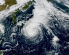
The Thermodynamic Engine: How Thermal Gradients Drive Rapid Intensification
Tropical cyclones operate as thermodynamic heat engines, converting latent heat flux from warm sea surface temperatures into kinetic energy. When examining the trajectory of Typhoon Dujuan across the western Pacific basin, analysts must first deconstruct the primary energy input function. Sea surface temperatures exceeding twenty-six degrees Celsius provide the foundational enthalpy required to sustain deep convective cloud bands. However, raw thermal availability alone fails to predict the velocity of intensification. The critical variable is the upper-level divergence field acting in concert with low-level moisture convergence.
As Dujuan tracked parallel to the Japanese island chain, particularly impacting the Izu archipelago and the Greater Tokyo Area, the system traversed oceanic zones characterized by localized thermal anomalies. Air-sea interaction parameters dictate that sensible and latent heat fluxes amplify exponentially when wind speeds breach specific thresholds, creating a positive feedback loop. Surface friction retards inflow angles, forcing parcels of air inward toward the center of low pressure while accelerating rotational velocity. Meanwhile, you can read other developments here: The Sirens Over Moscow When The Ballots Were Cast.
The structural mechanics of this intensification phase hinge upon the conservation of angular momentum. As inward-spiraling air conserves momentum while contracting toward the radius of maximum winds, minute variations in environmental shear dictate whether the vortex consolidates or dissipates. In Dujuan's operational lifecycle, intermittent vertical wind shear disrupted the convective core, inducing a cyclical weakening phase before thermal reinforcement allowed the system to regain typhoon characteristics. This oscillation highlights a core limitation in standard linear tracking models: weather forecasting systems frequently underestimate the nonlinear feedback between ocean heat content and eyewall replacement cycles.
Topographic Amplification: Why Island Chains Face Disproportionate Wind Shear
Topography alters local meteorology through mechanical forcing and friction differentiation. When a cyclonic vortex encounters an archipelago such as the Izu Islands, the interaction is governed by fluid dynamics principles rather than simple geographic intersection. Mountains and elevated volcanic landforms act as physical barriers that compress streamline flow, inducing local wind acceleration known as the Bernoulli effect. To explore the complete picture, we recommend the detailed analysis by USA Today.
On steep insular slopes like those found on Izu Oshima, rainfall totals accumulate rapidly due to Orographic lifting. Moist air forced upward by terrain barriers cools adiabatically, causing rapid condensation and extreme precipitation rates. This mechanism explains why peripheral storm tracks—systems that bypass mainland landfalls—frequently produce higher localized precipitation metrics than direct hits from faster-moving storms.
Furthermore, friction contrasts between ocean and land surfaces generate mechanical turbulence. The marine boundary layer features low roughness lengths, permitting high wind velocities to persist near the surface. Upon encountering rugged coastal landmasses, surface drag increases abruptly, tilting wind vectors and producing severe localized gusts. These gusts create extreme pressure differentials across structures, stressing architectural load limits beyond standard engineering tolerances designed for uniform directional wind loads.
The Infrastructure Cost Function: Quantifying Urban and Coastal Vulnerability
Critical infrastructure networks function as complex interdependent systems where failure in a single node propagates across secondary and tertiary sectors. During the passage of Dujuan, metropolitan transportation grids in the Greater Tokyo Area experienced cascading disruptions. The economic cost function of such meteorological events cannot be calculated solely through direct property damage; business interruption losses, logistics delays, and utility restoration expenditures dominate the aggregate financial impact.
Urban drainage systems present a primary bottleneck during high-intensity precipitation events. Standard municipal stormwater infrastructure is engineered to handle specific return-period rainfall intensities, typically calculated using historical climatological baselines. When convective systems deliver record-breaking rainfall over compressed timeframes—such as multi-hundred-millimeter accumulations within forty-eight hours—run-off coefficients spike. Drainage networks reach capacity thresholds, shifting surface water flow into underground rail terminals, roadway underpasses, and subterranean commercial basements.
Coastal defenses face a parallel structural challenge driven by compound flooding. Storm surge dynamics combine with astronomical tides and wave setup to elevate total water levels along exposed shorelines. Seawall engineering relies on static design water levels and wave height expectations. When high-frequency wave action breaches these barriers, the resulting kinetic energy strips coastal roads of asphalt matrices and destabilizes foundation pilings. The vulnerability is nonlinear: a linear increase in storm surge height yields an exponential increase in spatial inundation area across low-lying coastal plains.
Evacuation Latency and Behavioral Decision Theory Under Severe Weather Warnings
Emergency management systems operate under strict temporal constraints defined by evacuation latency—the duration required for an endangered population to receive, process, evaluate, and execute evacuation directives. When authorities issue high-level warnings, public response is mediated by subjective risk perception rather than objective meteorological data.
Behavioral inertia frequently delays protective action. Residents in urbanized coastal corridors often discount warnings if immediate local conditions appear benign prior to the arrival of the outer rainbands. This miscalculation stems from the "near-miss bias," where previous storms that generated minimal local damage diminish the perceived credibility of subsequent warnings. Consequently, municipal evacuation orders affecting over one million residents encounter compliance friction, clustering movement into compressed temporal windows immediately preceding peak storm intensity.
Logistical capacity restricts evacuation throughput. Railway suspensions and highway closures, implemented preemptively to prevent catastrophic transit accidents, paradoxically restrict the physical mobility required for population clearance. Emergency planners must balance the risk of transit infrastructure failure during a storm against the risk of stranding evacuees in transit corridors. This operational trade-off requires dynamic resource allocation algorithms that factor in real-time traffic density, public shelter capacity thresholds, and predicted wind shear limits for high-profile vehicles and rail rolling stock.
Maritime Logistics and Supply Chain Fragility in Archipelagic Geographies
Archipelagic economies depend heavily on maritime shipping and inter-island supply chains, making them acutely vulnerable to tropical cyclone disruptions. Port operations function as critical chokepoints; when meteorological agencies post gale or typhoon warnings, vessel traffic services mandate port closures, halting container handling and bulk cargo transfers.
The economic propagation of a port shutdown follows a distinct temporal decay curve. Buffer stocks in manufacturing and retail sectors absorb initial delivery delays, but prolonged port closures exceeding forty-eight hours trigger inventory stockouts. In the context of Japan's integrated supply chain networks, component delivery interruptions ripple rapidly into automotive and electronics assembly plants located hundreds of kilometers from the coastal impact zone.
Vessel routing strategies must adapt dynamically to avoid open-ocean encounters with intensifying cyclonic cores. Modern maritime navigation relies on ensemble weather prediction models to calculate optimal avoidance vectors, balancing fuel consumption penalties against structural safety margins. However, rapid intensification events like those observed during Dujuan's lifecycle reduce the reaction window for vessels operating in confined straits and coastal fairways, increasing the probability of emergency anchoring or drift-grounding scenarios in shallow coastal waters.
Meteorological Modeling Limitations and Ensemble Forecasting Variance
Operational numerical weather prediction models utilize grid spacing to simulate atmospheric physics governing tropical cyclone behavior. Global forecast models frequently struggle to resolve fine-scale convective processes and internal eyewall dynamics, leading to variance in track and intensity predictions.
Error cones expand as forecast horizons lengthen, introducing strategic uncertainty for municipal emergency planners who must commit resources days in advance of impact. The primary drivers of forecast variance include ocean heat content profile errors, inaccurate parameterization of cloud microphysics, and incomplete assimilation of upper-air sounding data over maritime expanses where observation stations are sparse.
Data assimilation improvements, including high-frequency satellite wind vector observations and autonomous oceanic glider deployments, have enhanced initial state characterization. Nevertheless, predicting the exact timing of secondary cyclogenesis or re-intensification phases remains an analytical challenge. Emergency response protocols must transition from static deterministic planning to probabilistic decision-making frameworks that incorporate full ensemble spread distributions, explicitly accounting for the tail risks associated with anomalous storm trajectories and unexpected rapid intensification cycles.
Resource Allocation and Long-Term Adaptation Frameworks for Insular Defense
Mitigating the systemic risks posed by intensifying tropical cyclones requires shifting from reactive disaster response models to proactive resilience engineering. Capital allocation must prioritize systemic hardening of vulnerable infrastructure nodes, including the decentralization of electrical grid distribution networks, the installation of automated subsurface flood barriers, and the retrofitting of coastal protection assets to withstand elevated wave energy regimes.
Strategic resource positioning must account for the high probability of isolated island communities experiencing prolonged utility outages and transport blockades following severe weather events. Establishing redundant communication channels, localized microgrid power generation capabilities, and strategic emergency supply stockpiles on individual islands reduces reliance on mainland supply lines during the immediate post-storm recovery window. Integrating multi-hazard risk assessments into municipal spatial planning ensures that future urban expansion avoids high-risk inundation zones, aligning demographic growth patterns with empirical climate vulnerability data.