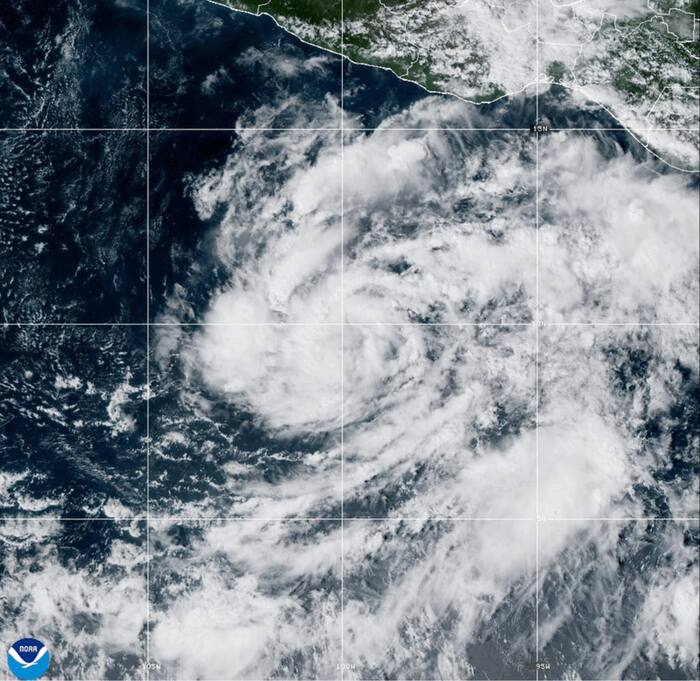
When Tropical Storm Vance formed in the eastern Pacific Ocean on October 21, 2026, a typical wire-service dispatch made it sound like a routine offshore spinner. About 520 miles south of Acapulco, Mexico, with initial maximum sustained winds near 40 mph, it didn't look like an immediate coastline crisis.
Honestly, treating a late-October Pacific storm as "no threat to land" on day one misses how fast tropical systems in this basin can change character. Over the next several days, Vance climbed well past its initial tropical storm threshold, reaching major-hurricane strength in early-morning readings on October 24 before fluctuating and later sending remnant moisture and swells toward western Mexico and the broader region.
Look closely at what happened with Vance, and you see two things at once. You see why early offshore advisories feel calm. You also see why late-season storms inside a record-setting Eastern and Central Pacific cycle deserve real respect.
How Tropical Storm Vance Built Out Over Open Water
Tracking a cyclone from a weak depression to a named storm and then a hurricane isn't magic. It's a slow accumulation of heat, moisture, and rotation.
Observations tracked the precursor system as a tropical depression starting October 18 over open water near 10.6°N, 89.2°W, with winds around 28 km/h and pressure near 1,011 mb. For a couple of days, it stayed modest, drifting westward while central pressure eased down. By October 21, organization picked up, and by 18:00 UTC that day it reached tropical storm status with sustained winds around 65 km/h (about 40 mph) and pressure near 1,003 mb south of Mexico.
Once a storm clears that initial hurdle in warm Pacific water, things can ramp up fast. By early October 23, Vance reached Category 1 strength, climbed to Category 2 later that day, and hit Category 3 at 00:00 UTC on October 24 with maximum sustained winds around 185 km/h and pressure near 961 mb.
That jump is the exact trap people fall into when they read a day-one headline. A 40 mph storm far off Acapulco isn't a hurricane yet. Yet the same warm ocean column that lets a system spin up to tropical storm strength can fuel rapid intensification if vertical wind shear stays low.
Why an "Offshore" Storm Still Matters Along the Coast
People hear "centered well out to sea" and mentally check out. Big mistake.
Even when a cyclone's center stays offshore, its wind field pushes long-period swells across hundreds of miles of open ocean. As Vance evolved and later weakened into remnants heading north-northeast toward western Mexico and the southern Baja California Peninsula, advisories from the National Hurricane Center warned about dangerous surf, rip currents, and heavy rainfall pockets across parts of western Mexico—with moisture reaching farther north as well.
Here's what usually trips travelers and coastal residents up:
- Calm skies on the beach don't mean safe water. Rip currents and heavy swells often arrive before local clouds thicken or winds pick up.
- Remnants still carry water. Once a cyclone loses hurricane winds, its leftover moisture plume can still dump heavy rain over steep terrain, triggering flash flooding or mudslides.
- Forecast cones aren't force fields. Small shifts in steering currents or forward speed change timing and rain totals fast.
I've watched plenty of beachgoers treat a distant storm like background noise because the sun was out. A storm doesn't need a direct landfall to make swimming hazardous or wash out mountain roads.
What This Storm Says About the 2026 Pacific Season
Vance didn't arrive in an average year. Across the Central and Eastern Pacific basins, 2026 racked up massive cumulative storm energy—pushing the Accumulated Cyclone Energy (ACE) index to a record 359.5, according to seasonal reporting on NOAA and National Weather Service data.
ACE isn't just a count of named storms. It combines storm intensity and duration over time, so a long-lived system that spins for days adds substantial energy even when its center stays mostly over water. That makes Vance a neat snapshot of the broader season: sustained tropical activity out in the basin, late-October persistence, and plenty of energy moving through the ocean-atmosphere system.
Meteorologists still debate exact attribution for individual storms—climate variability, sea-surface temperature patterns, and short-term atmospheric waves all play roles—so it's smart to stick to what's measurable. High ACE means the basin worked hard over the season. And late October in the Eastern Pacific sits right near the tail end of the official season, where systems can still pack punch even as seasonal conditions start shifting.
Practical Steps When a Pacific Storm Forms
If you're following a system like Tropical Storm Vance—whether you're planning a trip to Mexico, managing coastal property, or just tracking weather—skip the guesswork and run a simple checklist:
- Check official advisories, not viral social clips. Go straight to the National Hurricane Center for current coordinates, wind speeds, rainfall graphics, and marine warnings.
- Respect swell and rip-current alerts early. If local authorities or lifeguards flag rough surf, stay out of the water even if the storm center is hundreds of miles away.
- Watch rain totals near hills and rivers. Remnant moisture can cause rapid runoff and mudslides along steep terrain even after winds drop.
- Keep travel plans flexible around late-season systems. Build buffer days into flights or coastal drives when a tropical cyclone is churning nearby.