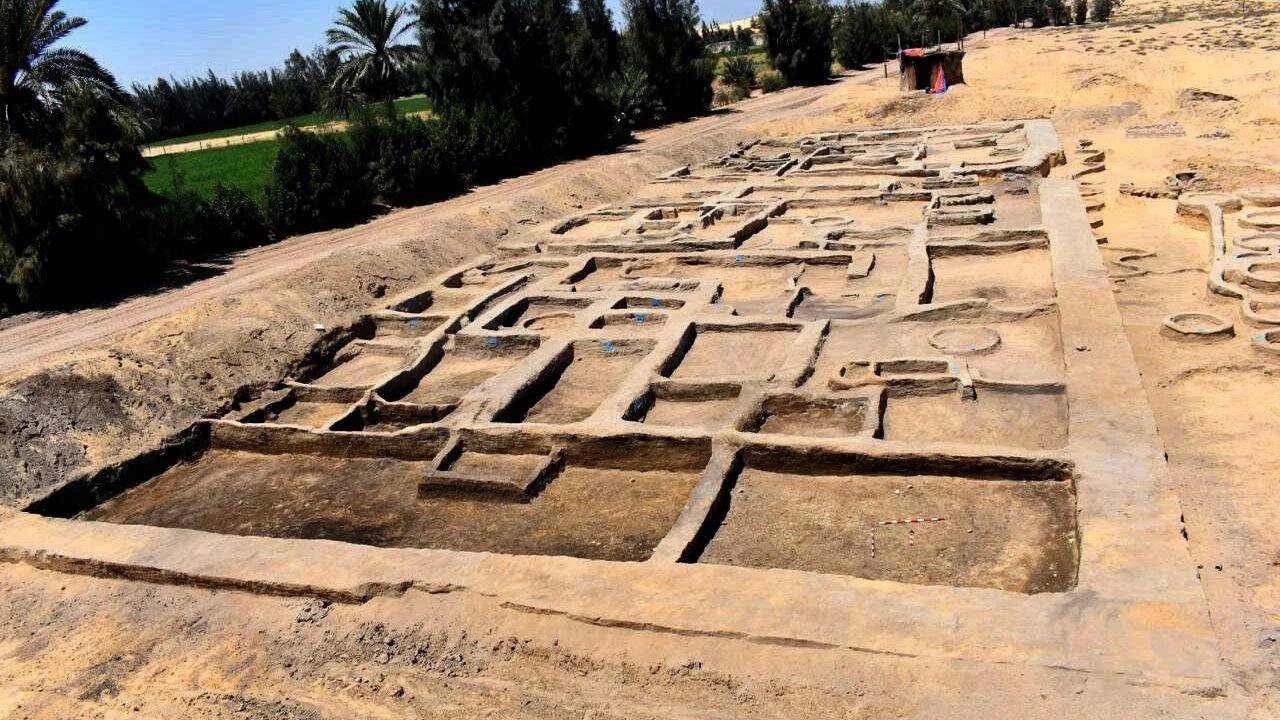
The recent identification of a residential complex in Tel El-Deir, Damietta, dating to the 26th Dynasty (circa 664–525 BCE), provides a high-resolution window into the logistical constraints of late-period Egyptian urban planning. While media reporting emphasizes the antiquity of these mud-brick structures, the operational value of the site lies in its demonstration of modular domestic architecture—a standardized construction method utilized to optimize land use in highly stratified riverine economies.
The Operational Framework of Ancient Mud-Brick Architecture
The structural integrity of the Tel El-Deir site relies on sun-dried mud brick (adobe). This material choice dictates the urban morphology of the Nile Delta. Unlike stone architecture reserved for mortuary or state cult functions, mud-brick residential zones prioritize thermal mass and space-efficiency.
Material Constraints and Thermal Dynamics
Mud brick functions as a high-heat-capacity insulator. By utilizing thick walls—typically 0.5 to 1.0 meters in depth—builders created a phase-shift thermal buffer. Solar radiation absorbed during the daylight hours is sequestered within the wall mass, releasing heat into the interior only during the nocturnal temperature drop. This passive climate control was the primary mechanism for habitability in the arid Delta environment.
Modularity as a Scalability Strategy
The discovered complex utilizes a grid-based spatial division. Archaeological evidence indicates that domestic units were clustered around shared courtyards. This indicates a "Cellular Housing Model":
- Shared Infrastructure: Walls were often doubled or shared between adjacent households to minimize raw material expenditure.
- Vertical Stratification: While primarily single-story, the foundations indicate structural reinforcement capable of supporting temporary roofing or light upper-level storage, increasing density per square meter.
- Spatial Hierarchy: Interior floor plans transitioned from public-facing workspace (craft zones) to private, restricted sleeping quarters, mirroring the social stratification of the Late Period.
Economic Indicators Derived from Domestic Contexts
The site offers more than architectural data; it serves as a ledger of economic activity. The discovery of terracotta vessels, bronze coins, and amulets within these residential boundaries allows for a quantitative assessment of household purchasing power and trade integration.
The Port Economy of Damietta
Damietta functioned as a critical node in the Mediterranean trade network. The presence of imported pottery shards—specifically East Greek wares—confirms that these residents were not subsistence farmers, but participants in a specialized maritime economy. Households functioned as micro-enterprises:
- Production: Presence of kilns and loom weights suggests domestic-scale manufacturing.
- Exchange: Proximity to the Damietta branch of the Nile provided direct access to upstream grain distribution and downstream maritime export hubs.
- Capital Accumulation: The recovered amulets and jewelry are proxy indicators of surplus wealth, suggesting the presence of a burgeoning middle class of merchants and administrators.
Resource Allocation and Scarcity
The density of the residential layout signals high land value. In the Nile Delta, arable land was the most contested resource. The choice to build vertically and compactly indicates that the opportunity cost of occupying fertile soil for housing was high. Consequently, urban expansion was strictly regulated by the state to preserve agricultural output, resulting in the "compact city" model observed at Tel El-Deir.
Comparative Chronology of Site Evolution
Understanding the 26th Dynasty requires situating this discovery against the broader trajectory of Egyptian settlement patterns. The following timeline tracks the shift from state-planned worker villages to organic, market-driven urban expansion.
- Middle Kingdom (c. 2000–1700 BCE): The Kahun Model. Rigid, orthogonal planning designed for state-mandated labor forces. High control, low economic autonomy.
- New Kingdom (c. 1550–1070 BCE): The Amarna Model. Introduction of the "Villa" concept for elites and sprawling, unplanned suburbs for the labor class. Increased social inequality.
- Late Period (c. 664–332 BCE): The Damietta/Tel El-Deir Model. A synthesis of density and trade-driven sprawl. The urban footprint is dictated by commercial throughput rather than pharaonic decree.
Analyzing the Artifact Assemblage
The functional categorization of artifacts recovered from the site provides a baseline for social stratification.
Utilitarian vs. Status Goods
The ratio of utilitarian ceramics to luxury imports serves as a Gini coefficient for the household. Households containing high volumes of amphorae used for oil and wine storage suggest commercial operations, whereas those containing faience amulets indicate disposal of symbolic capital. The specific concentration of bronze coinage found at Tel El-Deir is particularly significant; it marks a transition from a commodity-barter economy to a monetized system, reducing transaction costs for the residents.
Mortuary Integration
The discovery of funerary items within residential sectors is common in Late Period sites, reflecting a shift in the conceptualization of private space. The residence was no longer merely a site for living, but a hereditary asset linked to family lineage. By situating burials or small-scale shrines within or adjacent to the home, families asserted perpetual claim to the property.
Limitations of Current Archaeological Inference
While the residential complex provides significant data, analysts must account for preservation bias. Mud-brick structures are susceptible to erosion and agricultural encroachment. Consequently, the "complete" picture of the site is skewed toward the lower levels of the architecture.
- Selection Bias: Only the foundation layers and artifacts trapped under collapsed roof debris survive. Upper-story dynamics and wooden structural elements remain largely hypothetical.
- Sample Size: A single complex represents a micro-sample of the broader Damietta urban grid. Extrapolating city-wide population density from one quadrant risks significant error margins.
- Temporal Overlap: Residential sites were frequently repurposed over centuries. Attributing specific layers to the 26th Dynasty requires tight ceramic dating (stratigraphy) which can be obscured by later Roman-period disturbances.
Strategic Forecast for Site Development
Future research must move beyond descriptive cataloging toward predictive spatial modeling. The site’s potential as a historical asset is contingent on the integration of geophysical surveys with existing excavation data.
To maximize the intellectual output of the Tel El-Deir site, institutions should prioritize non-invasive sub-surface mapping. Ground-penetrating radar (GPR) across the surrounding fields will likely reveal the extent of the urban grid, allowing for the mapping of street layouts and water management systems. By identifying the connectivity between the residential zone and the harbor, archaeologists can quantify the precise logistical footprint of Late Period Egyptian trade. Data-sharing protocols between regional Egyptian authorities and international research bodies are the necessary prerequisite to building a comprehensive model of Delta urbanization.
:max_bytes(150000):strip_icc()/ar-American-Cheese-taste-test-horizon-4x3-54cc339550cd44b9a818c17bdfd5428d.jpg)