So, you’ve seen the movies. You’ve read Suzanne Collins’ trilogy and maybe the prequel about a young, terrifyingly ambitious Coriolanus Snow. But if you’ve ever tried to actually pin down where the map of Panem sits on a real-world globe, you know it’s a total mess. People get it wrong constantly. They assume everything stayed roughly the same, just with some extra water. It didn't.
Panem is a post-apocalyptic version of North America, sure. But it’s North America after catastrophic sea-level rise and a series of wars that basically wiped the slate clean. Honestly, the geography is the most underrated character in the whole series. It explains why some districts are rich, why others are starving, and why the Capitol is so dang hard to invade.
The Rocky Mountain Fortress: Finding the Capitol
The Capitol isn't just "out west." It’s very specifically nestled in what we call the Rocky Mountains. If you look at the terrain, it’s probably somewhere near the former Salt Lake City or perhaps Colorado. Why there? Because mountains are a natural fortress. You can’t just march an army of rebels into a high-altitude valley surrounded by peaks that touch the sky.
Suzanne Collins didn't just pick a random spot. The geography of the Capitol is a direct nod to its power. They control the high ground. In the books, Katniss describes the train rides moving through deep tunnels and over massive gorges. It’s isolated. It’s a literal ivory tower made of stone and recycled technology. When you look at the map of Panem, the Capitol is the center of the spiderweb, but it’s a center that's physically disconnected from the world it exploits.
District 12 and the Appalachian Reality
We know District 12 is Appalachia. That’s not a guess; it’s canon. But here’s the thing people miss: it’s tiny. It’s a "speck" compared to the sprawling industrial zones of the other districts. When you’re looking at the map of Panem, you have to imagine the coal-rich veins of West Virginia and Pennsylvania.
But wait. There’s a catch.
Since the sea levels rose, the East Coast is gone. Manhattan? Underwater. Washington D.C.? A swampy memory. This means District 12, which used to be inland, is now much closer to the coast than it was in our time. The "Seam" where Katniss lives is rugged, poor, and dirty because the environment itself is exhausted. It’s a stripped-back version of the American South and East, where the lush forests are the only things left after the mining companies took everything else.
The Problem With Fan Maps
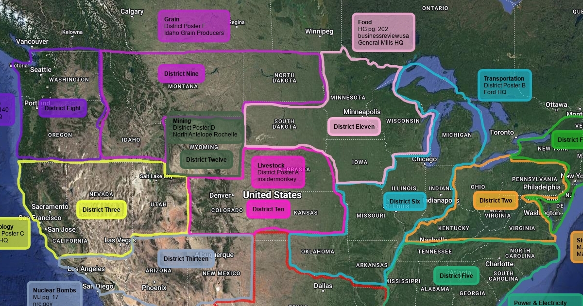
If you Google "Map of Panem," you’ll see dozens of colorful fan-made versions. Most of them are wrong. They often place District 4 (fishing) in the middle of the country or put District 7 (lumber) in the desert.
Realistically, District 4 has to be on the coast. But which coast? Most scholars and hardcore fans agree it’s likely the Pacific Northwest or what’s left of the California coastline. If the Gulf of Mexico expanded, District 4 could also be somewhere near the new "shoreline" of Texas or Louisiana. You’ve got to think about the ecology. You aren't catching salt-water fish in a landlocked state.
Why the Map of Panem Changes Everything
Geography is destiny. The Capitol didn't just draw lines on a map for fun; they organized the districts to prevent them from communicating. District 11 (agriculture) is huge. It has to be. It feeds the entire country. Most people place it in the Deep South—Georgia, Alabama, Mississippi. This makes sense for the climate, but it also creates a massive logistical nightmare for the Capitol.
How do you keep a massive, spread-out population of farmers from revolting? You isolate them. You put them in a place where there are no mountains to hide in.
Then you have District 13. For decades, people thought it was just a wasteland. But on the map of Panem, it was tucked away in the Northeast, probably near Maine or even parts of Canada. They were the nuclear district. They had underground bunkers. Because they were so far away from the Capitol—literally on the opposite side of the continent—they were able to survive in secret. Distance was their greatest weapon.
The Missing Pieces: District 13 and the Wild
The wilderness in Panem is "no man's land." Between the districts, there are hundreds, maybe thousands of miles of "nothing." In The Ballad of Songbirds and Snakes, we get a better look at how the Capitol viewed the edges of the map. To them, anything outside the district fences was a void.
But for people like Katniss and Gale, the map was a lie. They saw the woods as a source of life, not a boundary. The map of Panem isn't just a layout of cities; it’s a map of control. The fences are there to tell you where you aren't allowed to go.
A Quick Breakdown of Likely Locations:
- District 1 (Luxury): Near the Capitol. Probably Wyoming or Northern Utah. They’re the favorites, so they get to stay close to the party.
- District 2 (Masonry/Peacekeepers): The "Nut." We know this is in the Rockies. It’s essentially the Capitol’s military arm, carved into the mountains of Colorado.
- District 3 (Technology): Likely the former Silicon Valley or maybe the Seattle area, though some argue it’s more mid-western, like Chicago.
- District 7 (Lumber): Definitely the Pacific Northwest. Think Oregon and Washington. The giant trees are the giveaway.
- District 10 (Livestock): The Southwest. Texas, New Mexico, Arizona. Wide open plains for cattle.
Fact-Checking the Flooding
The official map released during the Catching Fire promotion showed a version of North America where the Great Lakes have merged and the Florida peninsula is totally gone. This isn't just "creative license." It’s based on actual projections of what happens if the polar ice caps melt completely.
When you study the map of Panem, you’re looking at a world where the geography has been simplified by disaster. The "Pan" in Panem comes from Panem et Circenses (Bread and Circuses), but the "Pan" also implies a unification—a forced one. The map is a tool of the state. By centralizing all resources and making each district specialize in only one thing, the Capitol made sure that no single district could survive on its own.
District 12 has fuel but no food. District 11 has food but no tech. District 3 has tech but no resources.
It’s a brilliant, cruel way to run a country. If you rebel, you starve. If you move, you're shot. The map is the cage.
How to Visualize the Districts Today
If you really want to understand the layout, don't just look at a flat image. Look at a topographical map of North America. Look at the mountain ranges. Look at the river systems.
The Capitol’s reliance on trains is a huge hint. Trains need tracks. Tracks are vulnerable. The entire rebellion in Mockingjay succeeded because the rebels finally understood the map of Panem better than the Capitol did. They didn't just fight soldiers; they fought the logistics of the land. They cut off the supply lines. They flooded the mines. They turned the geography against the people who used it to enslave them.
Honestly, the map is the key to the whole story. Without that specific, rugged, broken terrain, the Hunger Games wouldn't have worked. The distance created the mystery. The mystery created the fear.
To get a better handle on this, start by mapping the districts against modern-day climate change projections for the year 2100 and beyond. It’s terrifyingly accurate. You can also cross-reference the flora and fauna mentioned in the books—like the specific types of trees in District 7 or the migratory birds in District 12—to pin down latitudinal lines. The more you dig, the more you realize Suzanne Collins didn't just make this up; she rebuilt a continent based on ruin.
Practical Steps for Fans and Researchers:
- Overlay Climate Maps: Use a sea-level rise simulator (set to +200 feet) over a map of the US and Canada. This reveals the "new" coastlines of Panem.
- Track the Train Times: Re-read the first book and note how many hours Katniss spends on the train. Cross-reference this with the speed of modern high-speed rail to estimate the actual distance between District 12 and the Capitol.
- Identify the "Nut": Look for major military installations in the Rockies today. Cheyenne Mountain (NORAD) is the real-life inspiration for the rebel base in District 2.
- Analyze Soil Data: Research where the most fertile agricultural land in North America will be after significant warming. This helps place District 11 more accurately than just "the South."